REDWatch Waterloo Metro SSP and SSDA Submission
To: The Department of Planning
Attention: Director - Urban Renewal
Key Sites Assessments
RE: Submission on Waterloo Metro Quarter State Significant Precinct Planning Controls and State Significant Development Applications SSD 18_9393
REDWatch wishes to make a submission on the above SSP and SSDA.
REDWatch opposes the SSP rezoning proposal, as in its view, the supporting studies do not adequately deal with the matters raised in the study requirements. As a result, REDWatch urges DPE to require further work to be done on the SSP before the SSDA is assessed.
REDWatch also opposes the SSDA proposal as it is based on an inadequate SSP study and because it does not adequately address or mitigate the impacts of the proposed development on the surrounding area or the adjacent public housing community.
An inadequate SSP demographics data set and model
Central to REDWatch’s concerns are the way in which the demographic and social baseline studies deal with describing and projecting the community. Section 22.1 of the SSP study requirements states the demographic study is to “Determine the most suitable data set, model (or combination of models) and assumptions to be used to inform forecasts of future population and employment.”
REDWatch is concerned that the demographic study does not spell out its basis for its projections, and to the extent they are spelt out, REDWatch has major concerns about the adequacy of the model used. There is no discussion of other possible models or why the consultants chose the model used.
At the core of the demographic problem is that the studies cover two distinct communities that need to be understood separately and then projected forward into the projections. The two communities are:
1) The public housing community (2012 properties)
2) The private owners and renters within the 2016 Statistical area used in the studies (522 properties - 125 properties within Waterloo Estate SSP, 17 properties still occupied on the Waterloo Metro at time of census and 490 outside the Waterloo SSPs.
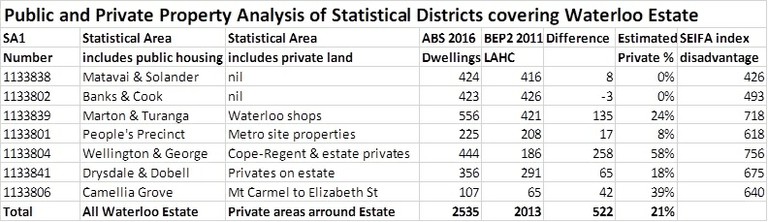
The demographics and social baseline studies take a current profile of the area as the seven statistical areas that overlap the Waterloo SSPs and then project on this basis. The table below shows how the SEIFA index of disadvantage changes across the seven SA1s in relation to the number of private residents.
To more accurately project, it is necessary to separately project the two very different tenant profiles that are to make up the 70% private and 30% social housing tenure mix proposed. The private projections in all likelihood would be projected in line with other inner city growth areas in parts of Green Square.
The current public housing community is an amalgam of distinct groups generated by successive government public housing policies. It contains an aging remanent of those who came into public housing when it was rental housing for working people (similar to contemporary affordable housing). Now that public housing is allocated on a needs basis many of the old working class tenants are being replaced by tenants with high and complex needs. These people are also placed on 2, 5 or 10 year tenancies rather than the indefinite tenancies of the early public housing system. To properly project this community it is necessary to factor in the demographics of those on the waiting list and the current allocations policy for social housing. Neither of these get a mention in the demographic projections. Many of these people are on disability pensions or other government benefits. Their potential employment interacts with their tenancy so that if they gain employment they potentially lose their tenancy. It is not uncommon that public housing tenants have to choose between keeping their home or taking a job. Much of this is driven by the structural disincentives between employment and the welfare safety net, as well as the lack of affordable housing that can allow people to stay in the area, keep their job and pay a rent affordable on their income.
To the extent that people in public housing die, gain employment and or move out of public housing, the expectation is that on average people of higher needs than those currently in public housing would replace them. The consequence of the government policy to place those in most need in public housing, in a system where housing stock does not keep pace with population growth, is that a successful transition program from social housing would see the level of need in public housing communities actually increase.
None of this complexity is reflected in the demographics. This complexity matters because there will be two very different populations post development. The private part of the future demographic will be high income in alignment with other parts of the inner city, the other community will be governed by the NSW Housing allocations policy which allocates housing to those most in need. This is not an average community it is a bi-modal community. By using the mean figures it masks the fact that it will contain two very different communities, with different needs, spending patterns, car usage and relationship to employment and business. What works for one community might not work in the same way, or at all, for the other.
An example of this is that the public housing community includes a significant concentration of people with mental health and cognitive impairment. Some of those people are supposed to be placed on the ground floor of buildings to help guard against anxiety or suicide risk. While there is a random distribution of potential “jumpers” in the community, that group is concentrated more in public housing because recent allocation policy is based on assessed high and complex needs. Design solutions for suitable high-rise public housing have to provide enough dwellings to as far as possible limit access to areas where people might be able to suicide. It also needs to have places where people can retreat when they feel overwhelmed.
We also do not have a clear idea of what the needs might be for tenants when the ABS figures are distorted by the 21% private returns. As an example, according to LAHC’s figures released in 2017 their records show that 30% of tenants are on Disability Support Pensions and that around 18% need assistance. The GHD report puts the need for assistance at only 11%, while anecdotally health workers put it at well over 20%.
The Metro Quarter sits alongside the Waterloo Estate development and while it will only contain 10% social housing, it needs to understand and respond to this demographic and to the adjacent bi-modal community with which it will interact.
REDWatch is very concerned that the proponents “most suitable data set” in the demographic and social baseline reports does not recognise the bi-modal distribution of its current community. Appendix 8 of the demographic study shows a graphic representation of the SA1s covering the estate, but it does not show that some of the area within the estate is also private. At no point does it seek to unpack the public / private housing make-up and the implications of the make-ups for projecting the seven SA1s. The GHD report misses three of the SA1s when it references them in it appendix.
One of the other concerns is that the demographics study does not deal with the accuracy of the census statistics. ABS has undertaken a number of promotions around census time to try to improve both return rates and the accuracy of returns in public housing. Neither of these two issues is addressed. It is well known that there are many unregistered tenants living in public housing and these are likely to go unreported also in the census figures. This is especially so in the 2016 census when it was widely announced that data would be shared with other parts of government. Because of these issues, local agencies are always uneasy about the use of census data to provide an accurate picture of the public housing community.
Are the growth projections correct?
If it is not possible to quantify the public housing and to know how many people already live here, a way to look growth in the community is by looking only at the growth in housing proposed. Based on the Metro SSP proposal and the just released Waterloo Estate preferred masterplan [6,800 units - 30% social, 5% affordable, 65% private] the proposal is to increase the total number of units on the SSP sites by 5,346. Of these, there will be 98 extra social housing units, 375 affordable housing units and 4,873 private units.
Based on the 2016 census figure of an average of 1.97 people per unit (https://profile.id.com.au/sydney/household-size) these 5,346 additional units could deliver an additional population of around 10,530. Id’s model on page 72 of the demographics study predicts an increase in population of 9,691 people from an increase of 5,313 new units. This equates to 1.82 people on average per residence. [REDWatch has not been able to establish the basis used for the starting point of 2,024 units which conflicts with 2012 public units, 125 privates on the estate and 17 units still showing on the partially resumed Metro Quarter in the 2016 census).
The demographics study does not disclose how it arrives at its figures so it is not possible to check why there is a difference in the estimates. Even if the 98 social and 375 affordable housing units had a lower occupancy rate, this does not seem to explain the differences. On the face of it the population growth projections are understated and the Department should ascertain why the average occupancy rates for the City of Sydney LGA are not applicable.
We suspect that the error comes from the base model used, which on average could be distorted by lower occupancies in public housing units. When projected this could underestimate occupancy and hence population growth.
In doing our analysis, we also analysed Figure 71 Assumed dwelling change – Waterloo Precinct in the demographic study. This showed an anomaly that no one has been able to explain to us. Upon analysis, the graph shows a nett reduction from the current stock of 2012 units of public housing of 600 or greater public housing units by 2029, 2030 and 2031. LAHC has advised REDWatch that this is not correct and there is no intention to undertake staging that would run down public housing other than in the initial stage. Where the SSP requests such projections, the results should realistically reflect what is likely to happen. In this case it does not.
Social Baseline Study Problems
REDWatch also notes that many issues have been identified in the GHD Social Baseline report. Attached is a copy of some of the issues identified by Groundswell Agencies. These errors may not invalidate the report’s ability to support increased planning controls, but if they were taken as an accurate representation of the human services and facilities available in Redfern and Waterloo, they would distort decisions about human services and facilities planning.
We find the GHD document a sub-standard document. Appendixes A & B purport to describe the statistical areas, but omits three of the seven SA1 areas used in the study. The Social Infrastructure needs assessment (Appendix H) is not mentioned in the table of contents nor is it discussed or even mentioned in the body of the report. There is no attempt to relate this aspect of the study to the rest of the “findings” in the baseline study.
Appendix D contains information on SLHD policy framework for Waterloo, but this is not reflected into the body of the GHD report. Health issues, and how they are dealt with, are a major concern for public housing tenants and a major Health Equity issue for SLHD. This is a major omission.
It is noted in Appendix H that SLHD “Advised that an integrated primary care facility is need in the town centre / metro quarter”. Table 13 | Outline of State and regional infrastructure associated with Waterloo Metro Quarter (Metro SSP Study p146) states that no health facilities are proposed for the Metro Quarter while the GHD report says there is a need for “Community health: one multi -purpose community and health centre of approximately 2,500 – 3,000 square metres” (Metro SSP Study P150).
REDWatch is particularly concerned that the Metro proposal does not contain the recommended community health centre. This is specifically of concern as “health facilities, primary health care services” has been added in the SSP requirements for Metro 8.7 when compared to SSD requirements for the Estate 8.8. “Health facilities” are only mentioned twice in the SSP requirements – here and in 7.1 in both sets of requirements.
The proponents need to explain why they have not included a health facility in the Metro proposal. The proponents have listed it as one of a range of community facilities that could be provided rather than something that will be provided. REDWatch, with other agencies, has been working closely with Sydney Local Health District in an attempt to improve its health service delivery to Waterloo.
SLHD was keen to see a health impact assessment included in the SSP requirements, but it did not eventuate. The current study does not deal with health issues in a satisfactory manner, especially in the way they affect the existing and future marginalised public housing community. One of the problems of not using a bi-modal population model is that the high needs of public housing tenants can be hidden or understated.
Some of the problem in overlooking public housing tenant issues lies within the GHD report methodology. While it talks about the need to accessing ‘on the ground knowledge’, it does not do it because GHD only did a desktop review, and even that not well. In its methodology section is has a section entitled “Definition of social sustainability” however at no point does it provide the definition. It does put up diagram from Berkley Group in Figure 5 of the ‘Four dimensions of social sustainability” but then looks almost exclusively in its analysis at Amenities (10 mentions) and Infrastructure (122 mentions). Voice and Influence is not explored in this study; Social and Cultural life, from other than a facilities angle, also is absence. Change in the neighbourhood is touched on a little, but not in relationship to the model.
Assessing cumulative impact
REDWatch is strongly of the view that the Waterloo Metro and Estate SSPs need to be assessed together and that it is unrealistic to assess them otherwise. For example, 50% of the public space in the Metro Quarter is supposed to get solar access. That will happen if what is on the Waterloo Estate site stays as it is, but it might not be the case when the Estate Metro Plan is finalised and buildings to the east and north may cast morning shadows over the public space at the Metro. The Waterloo Estate park has moved since the Metro proposal was submitted how does its shadowing now impact the proposal for the park and the buildings facing Cope Street?
Transport and traffic issues
Traffic is the other area where a cumulative approach must be made to determine if the site can carry the density applied for. The Metro report says the 700 units will generate 98 peak hour car movements (630 per day). With a proposed uplift from the estate preferred plan being 5436 units, on a pro rata basis the combined developments would deliver 756 peak hour car movements and 4,811 car movements a day.
These levels are unworkable for a site surrounded on three sides by roads taking arterial loads with little room for changing the traffic-light phasing. The key intersection for people needing to travel west is the most affected – the intersection of Botany Road, Henderson Road and Raglan Street. This intersection receives a Loss of Service rating of F with the average delay per vehicle in excess of 70 seconds at this intersection. The Metro traffic study says that by 2036 the morning delay at this intersection is expected to be 92 seconds and in the evening peak 107 seconds. The above station development, the report argues, will only add a second or two to these delays. The cumulative impact of the Metro and Estate developments will add a very much greater delay.
The traffic study was done before three bus routes (301, 302, 303) were re-routed to go through this intersection. The routes head west along Raglan Street reducing the number of cars that can exit the redevelopment area during a light cycle through Raglan Street. The return trip has the buses turning left from Botany Road into Raglan Street across the major pedestrian movement from the new station.
The traffic study suggests the bus stop next the Waterloo shops be moved to the middle of the Metro site block, which may work for buses that continue south down Botany Road but this will not work for the re-routed buses that drop at the Waterloo shops and then after George Street on Raglan Street. These new bus routes and their impact need to also be factored into the base and post development intersection modelling.
It is usual practice for the proponent to have to propose what is needed to bring intersections impacted by the development back to acceptable capacity. In this case, the proponent says the intersection is already bad and this development will not make it much worse. This argument can only work if you isolate the OSD from the Waterloo Estate. If the Metro delivers 99 peak hours vehicle movements then the combined SSP developments will deliver 756 peak hour vehicle movements on a prorate basis. Bringing the combined traffic impact into the picture, the proponents proposal that they need do nothing because their development only adds a second or two to already unacceptable average wait times cannot be accepted.
The proponent seems to admit that its decision to put a station at this location contributed significantly to the problem but then wants to duck any responsibility for it. For example, ‘Intersection modelling of the surrounding road network indicates that there would be an increase in average vehicle delay with Waterloo Station in 2036 due to the large increase in pedestrian demand, however additional impacts due to the Metro Quarter would be negligible’ and ‘Botany Road / Henderson Road / Raglan Street is forecast to experience delays with or without the Metro Quarter development by 2036’ (Waterloo Metro Quarter / State Significant Precinct Study page 130).
If possible the Department should not let the proponent through the SSP and SSDA part of the planning system duck responsibility for addressing the loss of service problem because the major problems at the intersection relate to impacts from an earlier SSI application by the same proponent.
Some possible change of light phasing is suggested, but given that Botany Road is a key arterial thoroughfare it is difficult to see phasing being changed to improve exit times out of the site at the expense of through arterial traffic.
REDWatch is of the view that the surrounding arterial capacity roads create a major constraint for car driven development within the Waterloo Metro and Estate developments. Either the proponents need to reduce the traffic generated by the development through tight restrictions on car parking availability (to reduce ownership and usage) or they must decrease the size of the development so it produces a workable level of peak hour car movements. Even then, REDWatch would argue that the proponent needs to come up with solutions that can deal with the level of traffic generated without further impacting the LOS on key intersections. Otherwise, there is a strong case that the site is not suitable for the level and type of development proposed.
REDWatch notes that there is a view among many public housing tenants that there should be parking with each unit. We note however that there will be only 70 public housing units in the Metro Quarter development. The more parking that is built in the more the people who buy into the site will expect to use cars. Minimal parking will attract buyers who do not own or want a car, with the consequence that there will be less people getting into cars and trying to leave the redevelopment area at peak and other times in a car.
For the combined proposal there needs to be a traffic desire line analysis so that paths for cars leaving and entering the estate from different directions can be assessed. As indicated earlier in this submission, for cars travelling west Raglan Street would be the existing desire line. It would then become possible to assess the likely wait times from various directions and not just the average wait times for all cars going through an intersection.
The main question to be answered in the SSP is what the appropriate controls for this site are. For REDWatch this question has not been appropriately answered. The traffic and transport study indicates that a low car proposal is required. The SSDA proposal doesn’t fulfil this.
Is the land usage approved appropriate?
It might be more appropriate for example, that the above station development be commercial space providing employment with minimal parking rather than residential, if the residential comes with significant parking. It is surprising that the proponents have not explored the possibility of greater commercial space on the site given the ease of access provided by the new Metro line.
Poor pedestrian movement
REDWatch is also especially concerned about the movements of pedestrians from the station and the development towards ATP as the major employer in the area. Because of the twin pair arterial roads and the station location, to get to ATP pedestrians will need to cross three streets (Raglan or Henderson, Botany Road and Wyndham Street). On a 120-second cycle, it will take up to 6 minutes waiting to “cross the road”. This is not a pedestrian friendly precinct for many who will live or arrive at the Metro Quarter.
When Premier’s Department came into Redfern in the early 2000s one of the issues it spent a lot of money on was trying to find a way to better connect Redfern Station and Redfern Street across the twin arterial roads. The Waterloo Metro development will create the same problem for people needing to cross to the ATP, Alexandria and the expanded campus of Alexandria Park Community School. The Metro development should be required to look at options for underground exits from the station especially to the western side of Botany Road for bus interchange.
REDWatch notes the plans include an optional mid-block pedestrian crossing across Botany Road however; the argument is that there is nothing to attract people to the other side. REDWatch contends that the west side bus interchange should be seen as the attractor irrespective of other attractors. If the west side bus interchange was moved close to the proposed mid-block crossing, interchange to north and south buses could share common wayfinding and be serviced through that pedestrian crossing taking some pressure off the Raglan Botany intersection pedestrian crossings and also increasing the number of cars that could left turn from Raglan Street within a cycle. Light phasing on the crossing could synchronise with the Raglan Street lights.
Is the quantity and administration of open space appropriate for the size of development?
REDWatch is concerned that there is only 15% open space in the SSP proposals. We appreciate that the City of Sydney has set this target for Central to Eveleigh corridor developments, but it is unclear to us if Council envisaged the very high-density proposal currently being proposed. Clearly the more people that you fit in a given area the greater the number of people that need to use the available open space. This is especially so for the public housing cohort. A Central Park type solution where grass gets worn out and replaced by AstroTurf or more hard surfaces does not deliver the open space amenity required in a high density development. REDWatch is of the view that the density proposed is excessive when seen alongside the public benefit.
REDWatch is also concerned that the public space will be administered by the development rather than by Council. Waterloo have had a number of problems over the year because open space has not been run by the local council. SLHD and LAHC have still not been able to reach an agreement after many years to allow health workers to pick up sharps on LAHC land like Waterloo Green.
Limited temporary Affordable housing
REDWatch has argued that the SSP developments, including the Metro site should deliver 10% affordable housing. If government owned land is not used to deliver significant quantities of affordable housing it will be difficult to see how the need for affordable housing will be met. On government land, the delivery of affordable housing should be required to meet the upper end of GSC range of 10% not the lower 5%. This is particularly important where social housing is provided so there is a transition mechanism for the so called “opportunity cohort” to move from social to affordable housing.
REDWatch certainly opposes the proposal that the affordable housing be only for 10 years. If Sydney Metro cannot make it the affordable housing in perpetuity the site should be left under the City of Sydney’s new affordable housing mechanism as this would result in long term affordable housing. Ten year affordable housing kicks the can down the road as a short-term measure. The initial extra housing this policy has produced will reach its 10-year marks soon forcing many people who have had, and continue to need, affordable housing back into the affordable housing market. Affordable housing on government owned land must be permanently gazetted.
The SSP and SSDA recognise the importance of the Aboriginal community to Redfern and Waterloo through art and cultural places. Ironically, however the local Aboriginal community is being driven out of the area because of a lack of affordable housing because of the gentrification of Redfern and Waterloo. There was a strong message out of the Visioning and Options Testing that there should be significant affordable housing delivered from these projects for specifically for Aboriginal families.
There is an over representation of Aboriginal people in public housing and some who live in the private market who bought property in the area when it was comparatively cheap or Aboriginal people who have high incomes and can afford to buy in the area. There is however almost no middle. Most Aboriginal kids who grow up in Redfern and Waterloo cannot afford move out to live in the area. They identify here and might come back and play for Redfern All Blacks, but cannot live in their traditional community.
REDWatch has argued that any redevelopment of Government land in Redfern and Waterloo needs to deliver 5% of the total hosing as affordable housing for low income Aboriginal working people. This is needed to maintain a viable mixed age and income community that can keep a viable Aboriginal community in Redfern and Waterloo into the future. If this does not happen we run the risk that, we will have artwork commemorating Redfern Waterloo as an historical Aboriginal centre but without a viable Aboriginal community living here creating a future for Aboriginal people in this place.
REDWatch proposed that of the 10% Affordable housing requested that half should be designated Aboriginal Affordable Housing and the other half provided for general affordable housing provision.
Sell off of Government Land opposed
Finally, REDWatch is opposed to the selloff of government land to fund public and affordable housing. Low income and key worker housing needs to be seen as part of the infrastructure provided for a viable long-term equitable community. The market cannot provide housing for low-income people on government benefits if it is not economic to do so. This is the point where the state needs to provide funding for accommodation for those in most need. It is also the point where the state needs to provide affordable housing for low waged workers providing key services for the city.
A model where the Government sells of government owned land to provide social and affordable is not supported by REDWatch. The proposal for build to rent models or other models that do not see scarce inner city land lost in the long run to social and affordable housing are preferred by REDWatch. For REDWatch potentially selling of 70% of social housing estates to renew 30% of social housing is not a viable long-term option, especially as the waiting list grows and public housing and lands are sold off to keep the remainder of the public housing system running.
Density is too great
REDWatch has sort to work closely with government agencies throughout the development of these plans and we welcome some of the improvements that have come from collaborations between Government, non-government and community groups. These have made improvements around the edges but not in REDWatch’s view addressed the key issue that the density proposed is too great for the location and the need for the public domain and open space to provide the level of amenity required for the bi-modal communities that will live around it.
This is especially important because the activation strategies used in many high density developments rely on a significant level of privatisation of the public domain through coffee shops, small bars and on street eating. To utilise these spaces you have to be a paying customer – what happens then to those on pensions and government benefits who cannot access these spaces where is their amenity? The retail study notes that the Waterloo shopping precinct is run down, but it is precisely this low cost precinct that services the existing public housing community. It was that community that fought for an Aldi supermarket in Waterloo. I am sure other low end chains would also bring retail offerings to the public housing tenants, but it is about more than low cost retail it is about low cost services, cheap coffee and beer and the other services they enjoy in that run down Waterloo precinct where rents are low enough to sustain these amenities.
There is much more work to be done to craft a community that will meet the needs of both ends of the income spectrum and for the reasons outlined in this submission we do not think the current proposal does that.
As a result, we urge DPE to require more work to be done on both the SSP, which we do not believe is adequate, and also on the SSDA which does not adequately address the impacts of the proposal on the surrounding area or the surrounding public housing community.
Yours Faithfully
Geoffrey Turnbull
REDWatch Co-Spokesperson
c/- PO Box 1567
Strawberry Hills NSW 2012
Ph Wk: (02) 8004 1490
Mob: 0401 529 931
email: mail@redwatch.org.au
REDWatch is a residents and friends group covering Redfern Eveleigh Darlington and Waterloo (the same area covered historically by the Redfern Waterloo Authority). REDWatch monitors government activities in the area and seeks to ensure community involvement in all decisions made about the area. More details can be found at www.redwatch.org.au.
APPENDIX:
Social Baseline Report Preliminary detail issues and comments
NOTE: REDWatch, like other NGOs, found it impossible to read both sets of documents in the time provided and to prepare a detailed submission. By necessity we limited our submission to some key issues we have raised publically and in our email updates.
