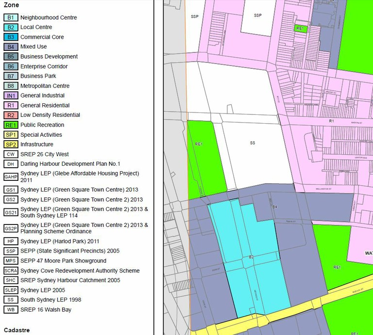
Land Use Zones Proposed for Waterloo South
Zone RE1 Public Recreation
1 Objectives of zone
- To enable land to be used for public open space or recreational purposes.
- To provide a range of recreational settings and activities and compatible land uses.
- To protect and enhance the natural environment for recreational purposes.
- To provide links between open space areas.
- To retain and promote access by members of the public to areas in the public domain including recreation facilities and waterways and other natural features.
- To protect sun access to publicly accessible land.
2 Permitted without consent
Environmental protection works
3 Permitted with consent
Aquaculture; Boat launching ramps; Boat sheds; Charter and tourism boating facilities; Centre-based child care facilities; Community facilities; Electricity generating works; Emergency services facilities; Environmental facilities; Food and drink premises; Horticulture; Information and education facilities; Jetties; Kiosks; Marinas; Markets; Recreation areas; Recreation facilities (indoor); Recreation facilities (major); Recreation facilities (outdoor); Registered clubs; Research stations; Respite day care centres; Roads; Roadside stalls; Signage; Water recreation structures; Water recycling facilities; Water supply systems
4 Prohibited
Any development not specified in item 2 or 3
Zone B2 Local Centre
1 Objectives of zone
- To provide a range of retail, business, entertainment and community uses that serve the needs of people who live in, work in and visit the local area.
- To encourage employment opportunities in accessible locations.
- To maximise public transport patronage and encourage walking and cycling.
- To allow appropriate residential uses so as to support the vitality of local centres.
2 Permitted without consent
Nil
3 Permitted with consent
Boarding houses; Centre-based child care facilities; Commercial premises; Community facilities; Educational establishments; Entertainment facilities; Function centres; Home industries; Information and education facilities; Medical centres; Oyster aquaculture; Passenger transport facilities; Recreation facilities (indoor); Registered clubs; Respite day care centres; Restricted premises; Roads; Service stations; Shop top housing; Tank-based aquaculture; Tourist and visitor accommodation; Any other development not specified in item 2 or 4
4 Prohibited
Depots; Extractive industries; Freight transport facilities; Heavy industrial storage establishments; Industrial retail outlets; Industries; Pond-based aquaculture; Storage premises; Transport depots; Truck depots; Warehouse or distribution centres
Zone B4 Mixed Use
1 Objectives of zone
- To provide a mixture of compatible land uses.
- To integrate suitable business, office, residential, retail and other development in accessible locations so as to maximise public transport patronage and encourage walking and cycling.
- To ensure uses support the viability of centres.
2 Permitted without consent
Home occupations
3 Permitted with consent
Boarding houses; Centre-based child care facilities; Commercial premises; Community facilities; Educational establishments; Entertainment facilities; Function centres; Hotel or motel accommodation; Information and education facilities; Medical centres; Oyster aquaculture; Passenger transport facilities; Recreation facilities (indoor); Registered clubs; Respite day care centres; Restricted premises; Roads; Seniors housing; Shop top housing; Tank-based aquaculture; Any other development not specified in item 2 or 4
4 Prohibited
Extractive industries; Heavy industrial storage establishments; Heavy industries; Pond-based aquaculture
Map Source: Exhibition Cadastre Zone map proposed for Waterloo (South) in exhibition documents
Description Source: https://legislation.nsw.gov.au/view/html/inforce/current/epi-2012-0628#pt
LEP Special Character Area - Restricted Retail Development
The planning proposal maps the site on the Retail Premises Map, in line with Sydney LEP 2012 controls. The George Street corridor is excluded from the Restricted Retail Premises provision, while the remainder of the site is subject to this provision. In accordance with Sydney LEP 2012 clause 7.23 ‘Large retail development outside of Green Square Town Centre and other planned centres’, larger retail premises (such as larger supermarkets) will be allowed along George Street but elsewhere shops and markets are limited to 1,000 sqm.
LEP Active Street Frontages Map
The planning proposal also maps Active Street Frontages in Sydney LEP 2012, along the extent of George Street and on corners and laneways extending off the sides of George Street. This mapping is used by clause 7.27 ‘Active street frontages’ and requires all premises on the ground floor of identified buildings to be used for the purposes of business premises or retail premises, and for those premises to have an active street frontage. This Planning Proposal expands the requirement to include all of the following uses on the ground floor of identified buildings in Waterloo Estate (South): business premises, retail premises, community facilities, health facilities, and centre-based childcare facilities. The proposal says that identifying George Street will ensure delivery of retail, business premises and community uses along the extent of the main street in the site, helping support a lively and continuous strip of activity, and providing convenient, easy access to retail by residents. Identifying side streets and laneways will deliver overflow and more affordable retail space, to support a diversity of uses and provide room for growth.
